Biomass
Antarctic ecosystem
Un-crewed aerial vehicle population survey of three sympatrically breeding seabird species at Signy Island, South Orkney Islands
Summary
Drone surveys provide an accurate method for counting seabird populations in Antarctica with minimal disturbance to wildlife compared to traditional ground-based surveys. The study validated drone methodology against ground counts at Signy Island for three seabird species. Drone counts were generally within 5% of ground counts, with high-resolution images allowing researchers to distinguish between similar penguin species. The study confirmed ongoing population trends: declining chinstrap penguins (70% decline since the 1970s) and increasing gentoo penguins (approximately 150% increase). Drones offer advantages including reduced disturbance to wildlife, permanent photographic records, and access to previously unreachable areas. The methodology provides a valuable tool for long-term seabird monitoring in polar regions.
1
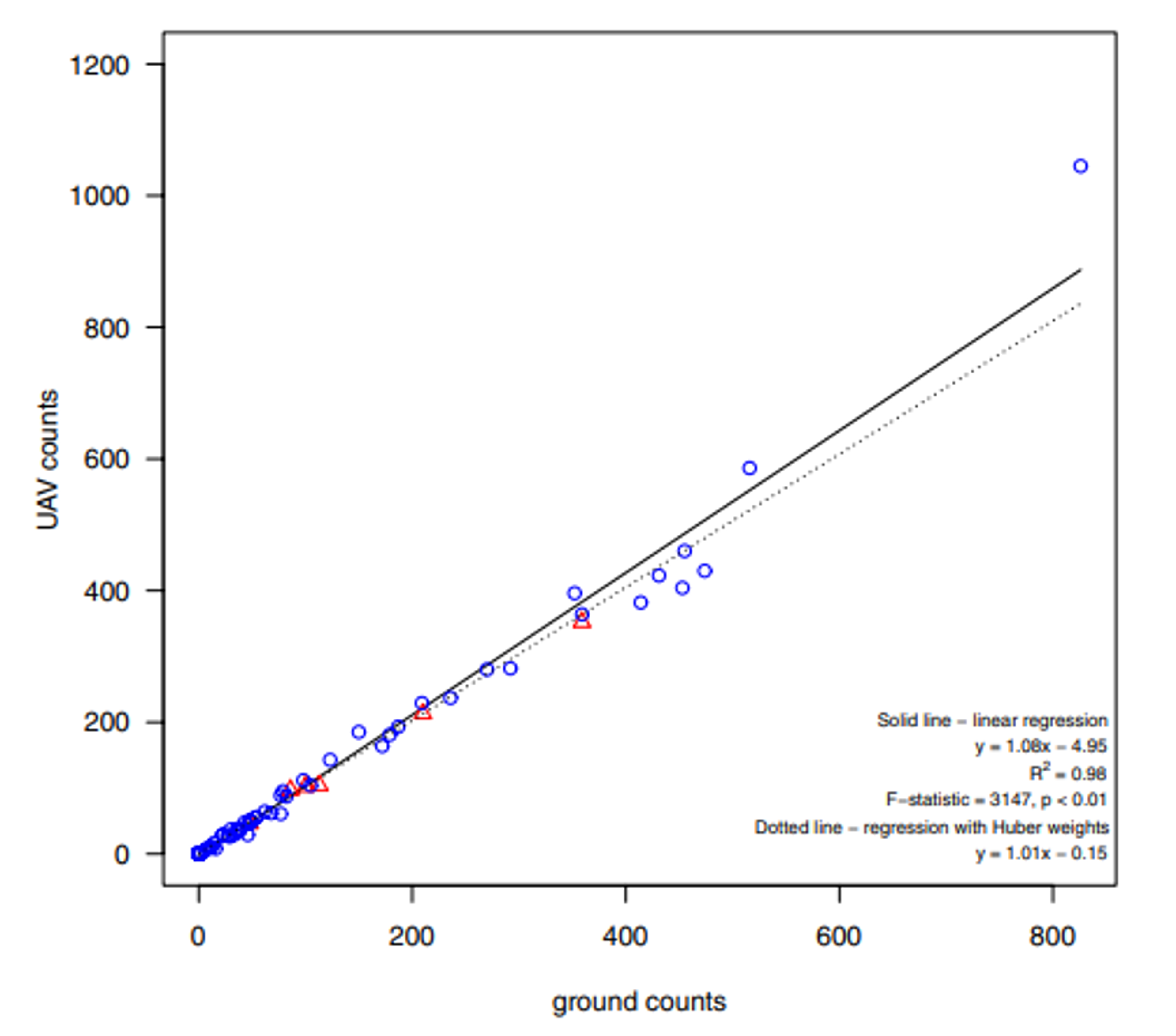
Comparison of penguin colony counts using drone surveys (y-axis) versus traditional ground counts (x-axis) at Signy Island. Blue circles show Chinstrap penguin colonies and red triangles show Gentoo penguin colonies. The close alignment along the diagonal line demonstrates that both counting methods produce nearly identical results, validating drones as an accurate alternative to ground-based surveys.Key Findings
1
Drone counts were within approximately 5% accuracy of ground counts for all three seabird species.2
High-resolution images taken from 35 meters altitude were sufficient to distinguish between similar penguin species.3
Population trends were confirmed: Chinstrap penguins continue declining (70% decrease since 1970s) while Gentoo penguins continue increasing (~150% growth).4
Drones enabled access to previously unreachable offshore islands for population surveys.Abstract
Surveying seabirds in polar latitudes can be challenging due to sparse human populations, lack of infrastructure and the risk of disturbance to wildlife or damage to habitats. Counting populations using un-crewed aerial vehicles (UAVs) is a promising approach to overcoming these difficulties. However, a careful validation of the approach is needed to ensure comparability with counts collected using conventional methods. Here, we report on surveys of three Antarctic bird species breeding on Signy Island, South Orkney Islands; Chinstrap (Pygoscelis antarctica) and Gentoo (Pygoscelis papua) Penguins, and the South Georgia Shag (Leucocarbo atriceps georgianus). We show that images from low-altitude UAV surveys have sufficient resolution to allow separation of Chinstrap Penguins from contiguously breeding Adélie Penguins (Pygoscelis adeliae), which are very similar in appearance when viewed from overhead. We compare data from ground counts with manual counts of nesting birds on images collected simultaneously by low-altitude aerial photography from multi-rotor UAVs at the same colonies. Results at this long-term monitoring site confirmed a continued population decline for Chinstrap Penguins and increasing Gentoo Penguin population. Although both methods provided breeding pair counts that were generally within ~5%, there were significant differences at some locations. We examine these differences in order to highlight potential biases or methodological constraints that should be considered when analysing similar aerial census surveys and comparing them with ground counts.Published in
Polar Biology
2021Authors
Dunn, M.J., Adlard, S., Taylor, A.P., Wood, A.G., Trathan, P.N., Ratcliffe, N.Institutions
British Antarctic Survey
Methods
Biological sampling DataField
Read the full paper
Go to doi.org